

NSW forest extent interactive reports
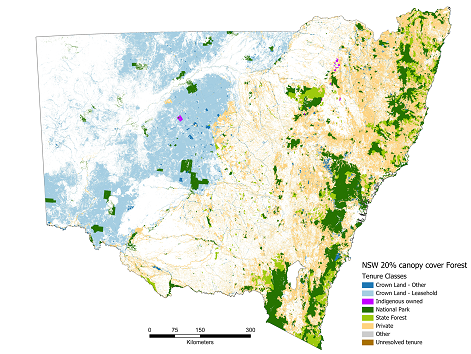
The 'NSW Forest area by Tenure' dashboards provide NSW forest extent by tenure over various administrative boundaries, allowing forest and natural resource managers, decision makers and researchers as well as the general public easy access to the most recent and accurate available information. The provided information represents indicator 1.1a* (Area of forest by forest type and tenure) for NSW forests.
*Indicator 1.1a - Area of forest by forest type and tenure: "The sustainable management and conservation of Australia's forests, whether on public or on private land, requires a sound understanding of their extent, type, use and management." (SOFR2018).
About the reports
The 'NSW Forest area by Tenure' reports are interactive visualisation (Microsoft PowerBI dashboards) of NSW forest area by tenure across various key administrative boundaries for forestry activities and operations.
The reports provide:
- Total NSW forest area by tenure;
- Percentage of the total NSW forest area by tenure;
- Detailed forest area by tenure over the selected region of interest e.g. Individual IBRA region; and
- Percentage of the detailed forest area by tenure over the selected region of interest, e.g. Individual IBRA region.
The dashboards use Landsat-derived forest layers with 20% canopy cover, sourced from the National Greenhouse Gas Inventory dataset (Forest and Sparse Woody Vegetation Data, Versions 3 and 7.0, released in 2018 and 2022 respectively), available on data.gov.au. These layers have a spatial resolution of 25m x 25m, which results in a different total forest area for NSW compared to other publicly available forest layers, such as the SOFR2018 layer with a 100m x 100m resolution. For example, the Landsat-derived forest layer used in the 2018 dashboards maps approximately 23 million hectares (Mha) of forest area across NSW in 2018, while the SOFR2018 layer shows around 20 Mha of forest.
How to use the dashboards?
To generate a report detailing forest area of your region of interest, either click on the interactive map or use the drop-down menu on top left corner and choose your region of interest.
For clearing the selection, simply click anywhere on the map box outside of the NSW area or unselect the selected region from the drop-down menu. If you used the search box, you will need to use the 'clear selections' icon located above the drop-down icon.
To generate reports using multi-page dashboards (the 2018 RFA & IFOA reports for example) for your areas of interest, you first need to navigate to the associated page using the page numbers at the bottom of the dashboard then select the region of interest.
To request the source data used for the analysis or for any other enquiries regarding the reports please contact Dr Masoomeh Alaibakhsh at masoomeh.alaibakhsh@dpird.nsw.gov.au.
NSW Forest extent by Type & Tenure dashboards, 2025
The 2025 interactive Power BI dashboards visualise the extent of forests across New South Wales UTM Zones 55 & 56, segmented by Forest Type and Forest Tenure, across:
- Local Government Areas (LGA) within UTM Zones 55 & 56,
- 10 Eastern IBRA regions, &
- Regional Forest Agreement (RFA) areas.
The 2025 dashboards are based on the 2022 NSW Forest Extent and NSW Land Tenure spatial layers, both developed by the NSW DPIRD – Forestry Research, Forest Resources team and available via the SEED data portal. The Plantation layer was provided by the DPIRD Plantation Unit in August 2024. The 2022 Forest extent spatial layer used for the 2025 dashboards illustrates 20% canopy cover forest extent over NSW UTM Zones 55 & 56. The layer was generated for forestry research and reporting purposes. Due to data accuracy issues the NSW UTM Zone 54 has not been mapped.


NSW Forest extent by Tenure dashboards, 2018
The NSW 2018 Forest extent dashboards provide data and insights regarding forest area by tenure across three different boundaries including;
- NSW IBRA7 regions,
- Integrated Forestry Operations Approvals (IFOA), and
- Regional Forest Agreement (RFA) areas.
The 2018 forest extent and tenure spatial datasets were also developed by the NSW DPIRD – Forestry Research, Forest Resources team.


Acknowledgements
The Forestry Research team acknowledges National Greenhouse Gas Inventory, NSW Spatial Services, Plantations Regulation unit and Forestry Corporation NSW for providing Woody vegetation, Private property, Plantation and Tenure layers utilised for producing the dashboards, and Peter Worsley and Ed Saunders for technical support.
