May 2026
 Hunter Local Land Services
Seasonal conditions in the Hunter remain challenging despite recent rainfall.
- Recent widespread rainfall in late May has provided some short-term relief, for parts of the region.
- Despite this, the region continues to be impacted by the effects of below average rainfall since the beginning of the year, resulting in low soil moisture, limited pasture growth and feed availability.
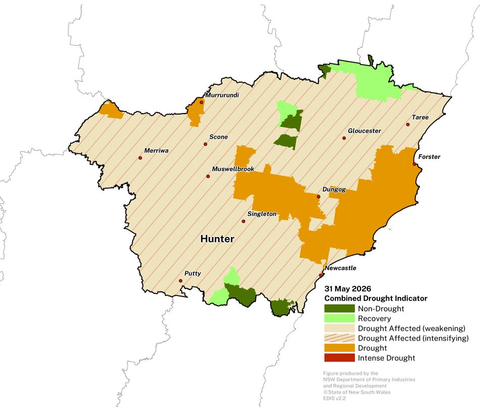
- Much of the region remains in the NSW-CDI Drought or Drought Affected categories.
- As the region enters winter, cooler temperatures, shorter daylight hours and the onset of frost are expected to further restrict pasture production.
- On ground reports suggest that many producers are currently supplementary feeding or considering feeding programs, reflecting ongoing concerns around feed availability and livestock condition.
Click on the scroll bar below the map to compare with previous months.
The DPRID Drought Forecast suggests that most of the region is likely to be in one of the NSW-CDI drought categories at the end of August 2026 (issued 31 May 2026).
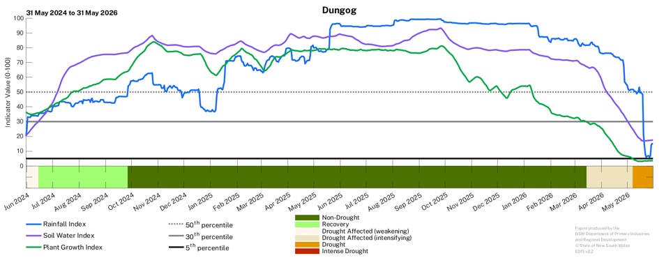
- Some areas will likely see drought conditions intensify and transition into the Drought category (e.g., around the Dungog region) or the most severe Intense Drought category (e.g. south of Taree).
- There is moderate to high model agreement and moderate to high past accuracy for this forecast period.
| NSW-CDI Category | April 2026 | May 2026 |
|---|---|---|
| Non-Drought | 23.5% | 7.7% |
| Recovery | 0.1% | 4.2% |
| Drought Affected - Weakening | 0.0% | 0.0% |
| Drought Affected - Intensifying | 70.4% | 75.6% |
| Drought | 6.0% | 12.5% |
| Intense Drought | 0.0% | 0.0% |
Normalised Difference Vegetation Index (NDVI)
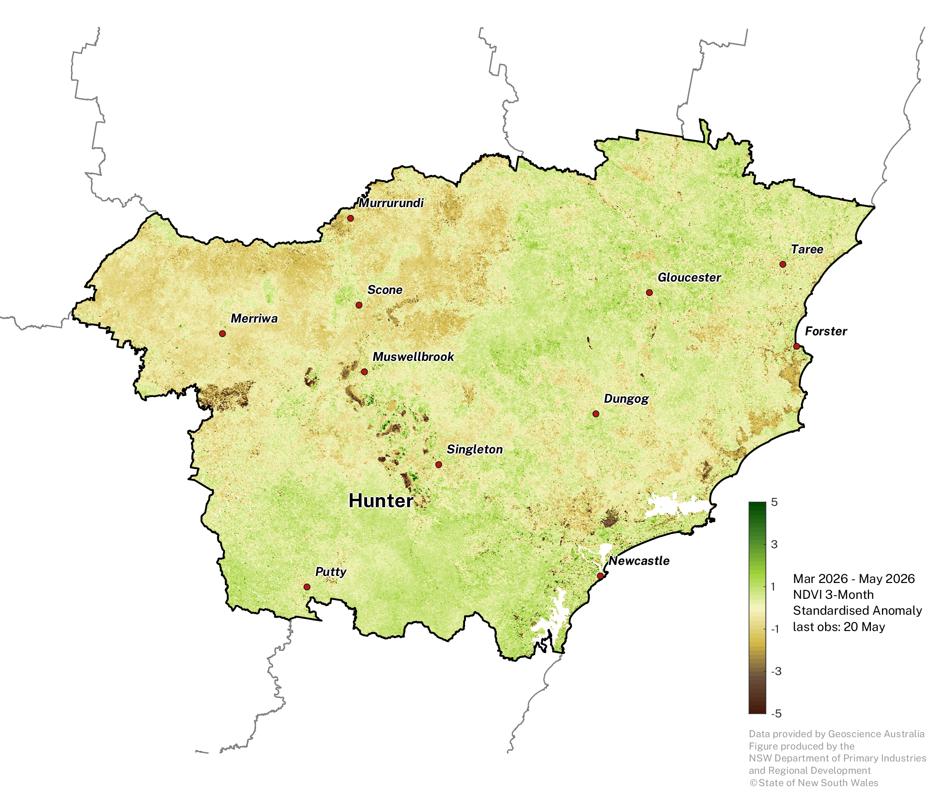
Plant greenness levels are highly variable across the region.
- Below average values are present in the west, and eastern parts of the region.
- The full influence of rainfall in late May will be available in the next Update.
- Note that some of the extremely negative NDVI areas (brown patches) are water bodies or from the influence of mining operations.
The NDVI anomaly is a useful measure of vegetation density and plant health. It estimates the amount of green vegetation there is in the landscape compared to what is expected at the given time of year, against the baseline period 1987 - 2020.
Click on the scroll bar below the map to compare with previous months.
Individual Drought Indicators
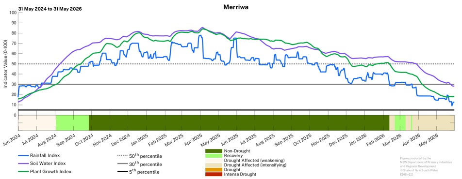
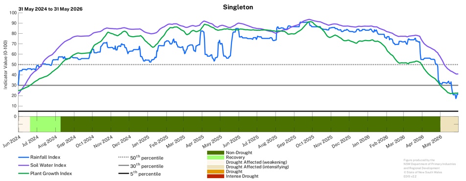
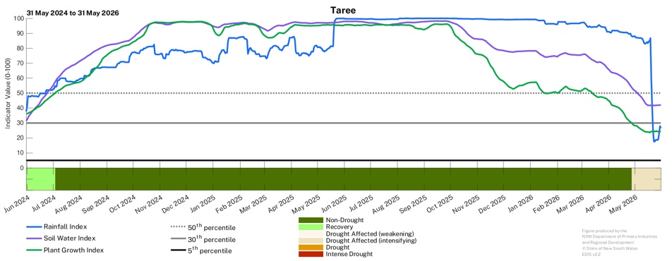
Declining drought indicators across much of the region.
- Autumn rainfall has been insufficient to improve the underlying indicators across the region.
- While late May rainfall has provided some short term relief, further rainfall and opportunities for plant growth will be needed to improve the underlying drought indicators across the region.
- Significant declines in the Rainfall (RI) and Plant Growth (PGI) Indicators are evident in many locations (e.g., Taree and Dungog).
- The rapid fall in the Rainfall Index at Taree during May 2026 reflects the intensity of the rainfall deficit experienced in the area over the last 3-4 months.
Observing the trends of the underlying drought indicators of Soil Water, Plant Growth and Rainfall is useful in tracking long-term changes in conditions.
Find out more about the underlying drought indicators here: https://www.dpird.nsw.gov.au/climate_applications/interactive-drought-map/Learn-more/understanding-the-cdi-phases
To access a Drought History chart for your Parish, visit the Seasonal Conditions Information Portal