

Key coastal habitats
Many important coastal environments have been impacted by flooding, such as smothering with sediment, die off due to prolonged freshwater or flood debris causing physical damage. Further, some existing land use management, particularly of drained coastal floodplain wetlands, will continue to pose risks to water quality and estuarine ecosystems in future floods, reducing the environmental resilience of these areas.
A range of projects are being implemented under the NEAP Program Action 4a. to assess these impacts, monitor recovery and work to implement on-ground works that will improve estuarine habitat condition and resilience, including:
- Mapping flood impacts on marine vegetation
- Coastal wetland reconnection and restoration
- Understanding flood effects on oyster reefs
- Rubbish clean-up efforts
- Bank stabilisation.

Coastal wetland rehabilitation
Coastal floodplain wetlands are a significant estuarine habitat type, particularly on the northern NSW coast.
Many of these coastal floodplain wetlands have been artificially drained through the installation of complex floodplain drainage infrastructure for many decades. This has led to degradation of this important habitat and environmental asset. Drainage has also increased the risk of impacts to the downstream estuary after floods, including the 2022 floods, via de-oxygenated (blackwater) and acidic water pollution events.
This Action will work with project partners to increase the environmental resilience of estuaries to floods through coastal floodplain wetland rehabilitation at several locations.
Check out our current projects listed below, including the REF for restoring tidal flows into Panboola wetlands at Pambula on the NSW far south coast and water quality analysis of Clybucca wetlands.
5b. Floodplain infrastructure
Floodgates, levees and drains are common infrastructure across most NSW coastal floodplains. They help to reduce the impacts of minor to moderate flood events and day to day tidal inundation on many communities, but this has had negative impacts on estuarine environments in many locations.
While in-river water levels ultimately control floodplain drainage, this infrastructure also influences post flood recovery from large over bank flood events. This has the potential to impact the downstream environment through the creation and release of poor water quality. Understanding these impacts, how to best manage this infrastructure, and its limitations now and into the future, is an important step to increasing the resilience of flood impacted estuaries.
Types of works funded include:
- assessment of priority hydrology management issues across floodplains and estuaries
- priority floodplain infrastructure construction projects including design, fabrication, and earthworks
- developing project planning and approval documentation
- flood vulnerability and constraints of coastal floodplain-built assets.
Get in touch with the NEAP Actions 4a. and 5b. team:
- Max Osborne (max.osborne@dpird.nsw.gov.au or 0428 153 686).
- NEAP Program Lead Kylie Russell (kylie.russell@dpird.nsw.gov.au or 0417 498 623).
Projects underway
Panboola
Options to increase the connectivity between the Pambula estuary and sections of coastal floodplain at Panboola within the Old Pambula Racecourse are being investigated. This will increase the health of the existing wetland area increasing its resilience, and that of the wider estuary, to future flood impacts.

Options to increase the connectivity between the Pambula estuary and sections of coastal floodplain at Panboola wetland within the Old Pambula Racecourse have been investigated.
The proposal will increase the health of the existing wetland area improving its resilience, and that of the wider estuary, to future flood impacts.
A Review of Environmental Factors has been prepared assessing the proposed works. See the links below for details. For more information on this project, contact Action lead max.osborne@dpird.nsw.gov.au.
- Panboola Wetland Rehab REF_Final_v1
- Panboola Wetland Rehab REF_Final_v1 Appendix A Project Plans
- Panboola Wetland Rehab REF_Final_v1 Appendix B Section 171 Checklist
- Panboola Wetland Rehab REF_Final_v1 Appendix C MNES
- Panboola Wetland Rehab REF_Final_v1 Appendix D Consultation
- Panboola Wetland Rehab REF_Final_v1 Appendix E Hydrology Assessments (10.5MB)
- Panboola Wetland Rehab REF_Final_v1 Appendix F Biodiversity Assessment (10.3MB)
- Panboola Wetland Rehab REF_Final_v1 Appendix G Due Diligence
- Panboola Wetland Rehab REF_Final_v1 Appendix H Background Searches
- Decision Statement - Panboola Wetland Rehabilitation Works
- Decision Statement - Pambula Estuary - Panboola wetland ~ Lot 6 and 8 DP1166672 Lot 1828 DP1187859.
Clybucca Wetlands
Assessing historical water quality data from Clybucca Creek and reviewing the effects of a temporary reintroduction of tide to the drainage network post flood. This analysis will assist planning for potential future changed management of the lower Clybucca floodplain wetlands.

The Clybucca Wetlands Tidal Inundation Assessment Project is underway. Detailed hydrology modelling will help refine rehabilitation options, update priority land acquisition zones, assess risks and benefits, and support planning for a potential blue carbon project.
A new report reviewing water quality at Clybucca (November 2021 – January 2025) is now available. It identifies key trends, examines the influence of the Menarcobrinni floodgates, compares recent and historical data, and benchmarks Clybucca Wetlands against another NSW coastal floodplain. The findings will help guide future management and assess impacts on the Macleay River estuary.

Malabar Creek and floodplain
A hydrologic assessment of the Malabar Creek and floodplain drainage system at Moruya, identified areas where saltmarsh was affected by poor tidal exchange.

Malabar Creek and floodplain
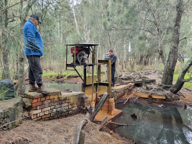
This project reviewed infrastructure influencing floodplain drainage, tidal exchange, and flood hydrology, like this levee.
Malabar Creek and floodplain
The effects of other infrastructure such as this wall and pump were also identified.
Report: A hydrologic assessment of the Malabar Creek and floodplain drainage system at Moruya.
Tuckean Swamp
Hydrological modelling is being updated at Tuckean Swamp to understand future sea level rise risks and assess possible tidal restoration scenarios. Information will be used to determine a preferred restoration option and inform planning for any restoration activities.

Everlasting Swamp
Contributing to the Everlasting Swamp Rehabilitation Project, a multi-agency project led by DCCEEW and NPWS. Developing a wetland restoration solution at the Everlasting Swamp National Park and State Conservation Area.

Floodplain infrastructure
Project partners, the University of New South Wales, will assess vulnerability and constraints of coastal floodplain-built assets, such as floodgates and drains, across flood impacted estuary floodplains.
This project will assist Councils and State Government Agencies to prioritise future investment and reduce the impacts of floods. Catchments to be assessed include Cudgen, Cudgera, Mooball, Brunswick, Belongil, Bellinger-Kalang, Nambucca, Camden Haven, Port Stephens and Hawkesbury-Nepean.
